

flood map.

|
The top flood map is for flood risks from rivers and seas and the second is flood risks to do with the surface water. The map shows the area of the site that could potentially flood from the rivers and the second is surface water flood.
|
selected site for bridge - map
|
A more detailed description [including analysis maps] of the canal area
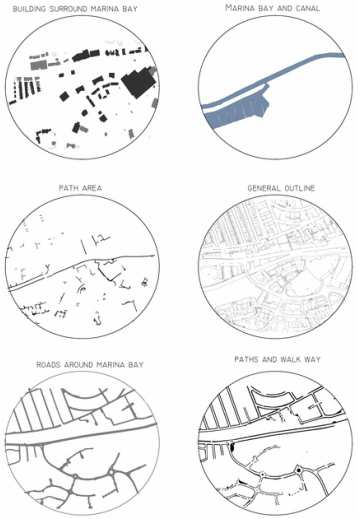
split map in to what are in the area of this site. - building surround marina bay - marina bay and canal - path area - general outline - roads around marina bay - paths and walk way. showing what elements of the maps takes up how much space and where. |
Existing bridge:

Existing bridge in the canal site.
distances of existing bridge and proposal.


|
Existing bridge with in the site:
The red line shows the bridge that's already on the site connecting the two side of the canal together. there are 3 bridges all together in the site. two of which are bridge which has pedestrian walk way and also has cars pass but the middle is a small steel and wooden bridge only for walk way and bicycle passing by. The map shows the distances of the the existing bridge and possibility of where the site could go, distances between the bridge are; marina bridge to Sainburys retail - 300 metres Sainburys retail park to option 1 site - 270 metres walking path bridge to second option - 160 metres second option to the final bridge cross at the locks - 357 metres. |
Site Selection 1 - analysis


|
52.946924, -1.163917
The option for the site is located between the first bridge and the second bridge 300 meters away from each other. right opposite from the retail park sainburys and the small grass site in the area. i made a map showing different layers of what the site consists of starting off with the nature (trees and the canal) |
Location of site:

